![](/images/other/stat-length.png)
![Excursión Bici de montaña La Trinité - Rando Téléthon La Trinité 2013 - Photo](https://media.geolcdn.com/t/1900/400/ext.pjpeg?maxdim=2&url=https%3A%2F%2Fstatic1.geolcdn.com%2Fsiteimages%2Fupload%2Ffiles%2F1524743154velo.jpg)
Rando Téléthon La Trinité 2013
boboazur
Usuario
![Longitud](/images/other/stat-length.png)
Longitud
31 km
![Altitud máxima](https://static1.geolcdn.com/siteimages/upload/files/1508320355ic_sort_altitude_max_24dp.png)
Altitud máxima
354 m
![Desnivel positivo](https://static1.geolcdn.com/siteimages/upload/files/1508320355ic_sort_den_pos_24dp.png)
Desnivel positivo
988 m
![Km-Effort](/images/other/stat-length.png)
Km-Effort
45 km
![Altitud mínima](https://static1.geolcdn.com/siteimages/upload/files/1508320355ic_sort_altitude_min_24dp.png)
Altitud mínima
78 m
![Desnivel negativo](https://static1.geolcdn.com/siteimages/upload/files/1508320355ic_sort_den_neg_24dp.png)
Desnivel negativo
990 m
![Boucle](https://static1.geolcdn.com/siteimages/upload/files/16400158638029165_repeat_loop_refresh_sync_direction_icon.png)
Boucle
Sí
Fecha de creación :
2014-12-10 00:00:00.0
Última modificación :
2014-12-10 00:00:00.0
![Bici de montaña](https://static1.geolcdn.com/sitytour/trail-icons/202.png)
2h53
Dificultad : Medio
![Escanee este código QR para abrir la excursión en la aplicación SityTrail](https://capi.geolives.com/qq0zvz2zws4bq2lad0pu/sitytour/trails/236394/qr.png?size=200)
Aplicación GPS de excursión GRATIS
A propósito
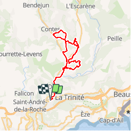
Ruta Bici de montaña de 31 km a descubrir en Provenza-Alpes-Costa Azul, Alpes Marítimos, La Trinité. Esta ruta ha sido propuesta por boboazur.
Descripción
Rando organisée par le club vtt de La Trinité pour le Téléthon 2013. Possibilité de partir depuis la pointe de Contes pour eviter la liaison plate sur route. Rando type enduro.
Localización
País:
France
Región :
Provenza-Alpes-Costa Azul
Departamento/provincia :
Alpes Marítimos
Municipio :
La Trinité
Localidad:
Unknown
Salida:(Dec)
Salida:(UTM)
364314 ; 4844630 (32T) N.
Comentarios
Excursiones cerca
![Excursión Senderismo Niza - Ballade chemin des douaniers Nice-Villefranche - Photo](https://media.geolcdn.com/t/375/260/c2d5ab1c-da60-4999-9c1c-1e8798e5ba02.jpg&format=jpg&maxdim=2)
![Senderismo Senderismo](https://static1.geolcdn.com/sitytour/trail-icons/101.png)
Ballade chemin des douaniers Nice-Villefranche
Senderismo
Muy fácil
(1)
Niza,
Provenza-Alpes-Costa Azul,
Alpes Marítimos,
France
![](/images/other/stat-length.png)
7,9 km | 10,3 km-effort
2h 13min
![](https://static1.geolcdn.com/siteimages/upload/files/16400158638029165_repeat_loop_refresh_sync_direction_icon.png)
No
![Excursión Senderismo Cantaron - Cantaron : Monts Macaron et Ubac par Levens Tourette réelle - Photo](https://media.geolcdn.com/t/375/260/60da6868-ad90-4803-993b-f92b5b64ec1d.jpg&format=jpg&maxdim=2)
![Senderismo Senderismo](https://static1.geolcdn.com/sitytour/trail-icons/101.png)
Cantaron : Monts Macaron et Ubac par Levens Tourette réelle
Senderismo
Muy difícil
Cantaron,
Provenza-Alpes-Costa Azul,
Alpes Marítimos,
France
![](/images/other/stat-length.png)
19,7 km | 35 km-effort
7h 57min
![](https://static1.geolcdn.com/siteimages/upload/files/16400158638029165_repeat_loop_refresh_sync_direction_icon.png)
Sí
![Excursión A pie Èze - Circuit du mont Bastide - Photo](https://media.geolcdn.com/t/375/260/5ad7717b-c841-4266-a29b-c036d9f61957.jpeg&format=jpg&maxdim=2)
![A pie A pie](https://static1.geolcdn.com/sitytour/trail-icons/100.png)
Circuit du mont Bastide
A pie
Fácil
Èze,
Provenza-Alpes-Costa Azul,
Alpes Marítimos,
France
![](/images/other/stat-length.png)
7 km | 14,7 km-effort
3h 20min
![](https://static1.geolcdn.com/siteimages/upload/files/16400158638029165_repeat_loop_refresh_sync_direction_icon.png)
Sí
![Excursión Senderismo Èze - Mont Bastide, sentier de Nietzsche - Photo](https://media.geolcdn.com/t/375/260/ext.jpg?maxdim=2&url=https%3A%2F%2Fstatic1.geolcdn.com%2Fsiteimages%2Fupload%2Ffiles%2F1553511878bg_sport_marche.png)
![Senderismo Senderismo](https://static1.geolcdn.com/sitytour/trail-icons/101.png)
Mont Bastide, sentier de Nietzsche
Senderismo
Fácil
(1)
Èze,
Provenza-Alpes-Costa Azul,
Alpes Marítimos,
France
![](/images/other/stat-length.png)
7,2 km | 15,1 km-effort
3h 15min
![](https://static1.geolcdn.com/siteimages/upload/files/16400158638029165_repeat_loop_refresh_sync_direction_icon.png)
Sí
![Excursión Senderismo Èze - eze 221213 - Photo](https://media.geolcdn.com/t/375/260/ext.jpg?maxdim=2&url=https%3A%2F%2Fstatic1.geolcdn.com%2Fsiteimages%2Fupload%2Ffiles%2F1553511878bg_sport_marche.png)
![Senderismo Senderismo](https://static1.geolcdn.com/sitytour/trail-icons/101.png)
eze 221213
Senderismo
Medio
(1)
Èze,
Provenza-Alpes-Costa Azul,
Alpes Marítimos,
France
![](/images/other/stat-length.png)
9,9 km | 14,7 km-effort
2h 4min
![](https://static1.geolcdn.com/siteimages/upload/files/16400158638029165_repeat_loop_refresh_sync_direction_icon.png)
Sí
![Excursión Senderismo Villefranche-sur-Mer - Balcons de Beaulieu 11.1.24 - Photo](https://media.geolcdn.com/t/375/260/b25ef240-7e5d-488d-86bf-1cb2f63b1b2e.jpg&format=jpg&maxdim=2)
![Senderismo Senderismo](https://static1.geolcdn.com/sitytour/trail-icons/101.png)
Balcons de Beaulieu 11.1.24
Senderismo
Medio
Villefranche-sur-Mer,
Provenza-Alpes-Costa Azul,
Alpes Marítimos,
France
![](/images/other/stat-length.png)
8 km | 13,7 km-effort
2h 30min
![](https://static1.geolcdn.com/siteimages/upload/files/16400158638029165_repeat_loop_refresh_sync_direction_icon.png)
Sí
![Excursión Senderismo Niza - Nice cathédrale Russe - Photo](https://media.geolcdn.com/t/375/260/a2805ec0-0633-4ac1-93e3-767707679f1d.jpg&format=jpg&maxdim=2)
![Senderismo Senderismo](https://static1.geolcdn.com/sitytour/trail-icons/101.png)
Nice cathédrale Russe
Senderismo
Muy fácil
Niza,
Provenza-Alpes-Costa Azul,
Alpes Marítimos,
France
![](/images/other/stat-length.png)
6,9 km | 7,8 km-effort
2h 10min
![](https://static1.geolcdn.com/siteimages/upload/files/16400158638029165_repeat_loop_refresh_sync_direction_icon.png)
Sí
![Excursión Senderismo Cantaron - Cantaron : Monts Macaron et Ubac - Photo](https://media.geolcdn.com/t/375/260/0c099172-d426-4bc6-b370-544c7fbae01b.jpg&format=jpg&maxdim=2)
![Senderismo Senderismo](https://static1.geolcdn.com/sitytour/trail-icons/101.png)
Cantaron : Monts Macaron et Ubac
Senderismo
Medio
Cantaron,
Provenza-Alpes-Costa Azul,
Alpes Marítimos,
France
![](/images/other/stat-length.png)
19 km | 34 km-effort
7h 47min
![](https://static1.geolcdn.com/siteimages/upload/files/16400158638029165_repeat_loop_refresh_sync_direction_icon.png)
Sí
![Excursión Senderismo Niza - Nice - Tour du Mont Boron - Photo](https://media.geolcdn.com/t/375/260/bd67743c-530f-4072-b544-a2d6a051157c.jpg&format=jpg&maxdim=2)
![Senderismo Senderismo](https://static1.geolcdn.com/sitytour/trail-icons/101.png)
Nice - Tour du Mont Boron
Senderismo
Fácil
(1)
Niza,
Provenza-Alpes-Costa Azul,
Alpes Marítimos,
France
![](/images/other/stat-length.png)
7,3 km | 10,5 km-effort
2h 48min
![](https://static1.geolcdn.com/siteimages/upload/files/16400158638029165_repeat_loop_refresh_sync_direction_icon.png)
Sí